Sign In Start Free Trial
Account

Add to playlist

Create a Playlist

Modal Close icon
You need to login to use this feature.
  • Learn QGIS
  • Toc
  • feedback
Learn QGIS

Learn QGIS

By : Cutts, Anita Graser
2 (1)
close
Learn QGIS

Learn QGIS

2 (1)
By: Cutts, Anita Graser

Overview of this book

QGIS 3.4 is the first LTR (long term release) of QGIS version 3. This is a giant leap forward for the project with tons of new features and impactful changes. Learn QGIS is fully updated for QGIS 3.4, covering its processing engine update, Python 3 de-facto coding environment, and the GeoPackage format. This book will help you get started on your QGIS journey, guiding you to develop your own processing pathway. You will explore the user interface, loading your data, editing, and then creating data. QGIS often surprises new users with its mapping capabilities; you will discover how easily you can style and create your first map. But that’s not all! In the final part of the book, you’ll learn about spatial analysis and the powerful tools in QGIS, and conclude by looking at Python processing options. By the end of the book, you will have become proficient in geospatial analysis using QGIS and Python.
Table of Contents (8 chapters)
close

Raster data

Raster data is not created like vector data. Quite often, raster data is created from other raster data, such as creating a slope raster from a topographic raster. Raster data can also be created from vector data, which can be done by gridding a series of coordinates/points. QGIS has the ability to perform all of these functions. We will further explore raster visualization in Chapter 4, Creating Great Maps, and processing rasters in Chapter 6, Extending QGIS with Python.

In this section, we will convert our Canada_Provinces.shp to a raster. In the menu, click Raster | Conversion | Rasterize (vector to raster), as shown in the following screenshot:
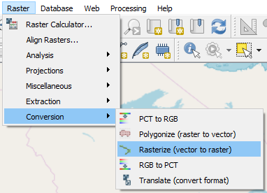
Vector to raster

In the following dialog box, enter these parameters:

  • Input Layer: Canada_Provinces.
  • Burn-in value: id.
  • Output raster size units: Pixels.
  • Width: 10 (this will create a raster with a width of 10 pixels...
bookmark search playlist download font-size

Change the font size

margin-width

Change margin width

day-mode

Change background colour

Close icon Search
Country selected

Close icon Your notes and bookmarks

Delete Bookmark

Modal Close icon
Are you sure you want to delete it?
Cancel
Yes, Delete